Geo Surveying Services is a single point of access to Geo-information. Geo Surveying Services acquires, processes and integrates geographic and spatial data, covering all geographic data development stages, including satellite imagery, Mapping, Topographic and Marine surveys, Surveying Equipment and Accessories, Remote Sensing, Training courses in GPS and GIS and consultancy.

EFIX

About Geo Surveying Services
Geo Surveying Services is a single point of access to Geo-information. Geo Surveying Services acquires, processes and integrates geographic and spatial data, covering all geographic data development stages, including satellite imagery, Mapping, Topographic and Marine surveys, Surveying Equipment and Accessories, Remote Sensing, Training courses in GPS and GIS and consultancy.
Geo Surveying Services is a team of experts providing professional, quality, accurate and cost-effective consulting, engineering and marketing services in Lebanon and the surrounding regions since 2008.
  -->

We are delivering Latest Products for you


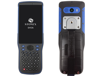
STONEX SH5A
SH5A Rugged Controller device, Internal GNSS, 5" screen, Full Keyboard
 
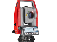
PENTAX 2500NS
Long EDM range measuring distance: reflectorless up to 600m and up to 7,000m in prism mode
 
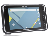
Handheld Algiz-RT8

The Algiz RT8 is a unique 8-inch Android tablet computer built
specifically to increase fieldwork efficiency

LATEST NEWS & EVENTS

Geo Surveying Services is a team of experts

Geo Surveying Services is a team of experts providing professional, quality, accurate and cost-effective consulting, engineering and marketing services in Lebanon and the surrounding regions since 2008.

GSS has wide first-hand experience and a wealth of practical knowledge gained in the above listed services with a diversity of specialized evaluation software as well as the capabilities to operating challenging analyses.

EXPLORE MORE ABOUT US
WHAT WE ARE OFFERING YOU

3D MODELLING

3-D modeling is the use of software to create a virtual three-dimensional model of some physical object.

Read More

DIGITAL ELEVATIONS

A Digital Elevation Model (DEM) represents the 3D shape of a terrain in a digital format

Read More

GIS and remote sensing

Remote sensing and GIS explores the use of technologies to gather information about the earth we live on

Read More

Ortho Imagery

Satellite imagery and aerial photographs play an important role in general mapping

Read More

Satellite Imagery

GeoSurveying Services delivers high and medium resolution satellite imagery to help users identify the best solution for their projects

Read More

Service & Support

We provide a wide range of professional support and services to meet your needs.

Read More

Training courses in GPS and GIS

Geo Surveying Services offers based training services to help you be productive with all our Hardware and software. We offer the basic and advanced training courses for surveying. GNSS (Global NAVIGATION SATELLITE SYSTEM) GIS Remote Sensing Civil 3D Pix4D

Read More
OUR PARTNER
CARLSON
CONCOX
Dji
GARMIN
HANDHELD
JIMI
ORIENT
PENTAX
PIX4D
SEAFLOOR
SPACEWILL
STONEX